
5 ways nature tech can bring integrity and scale to nature-based solutions
How Satellite Imagery helps in Nature Measurements
A 2023 report from the World Economic Forum emphasized that nature loss is a top five risk for global businesses, with 85% of respondents to their Executive Opinion Survey recognising biodiversity loss as a critical business concern.

We cannot manage or change something that we cannot measure. Measuring the true value of a nature asset is critical to the flow of sustainable environmental and financial returns from nature investments.
Understanding Satellite Data for Detecting Carbon Storage
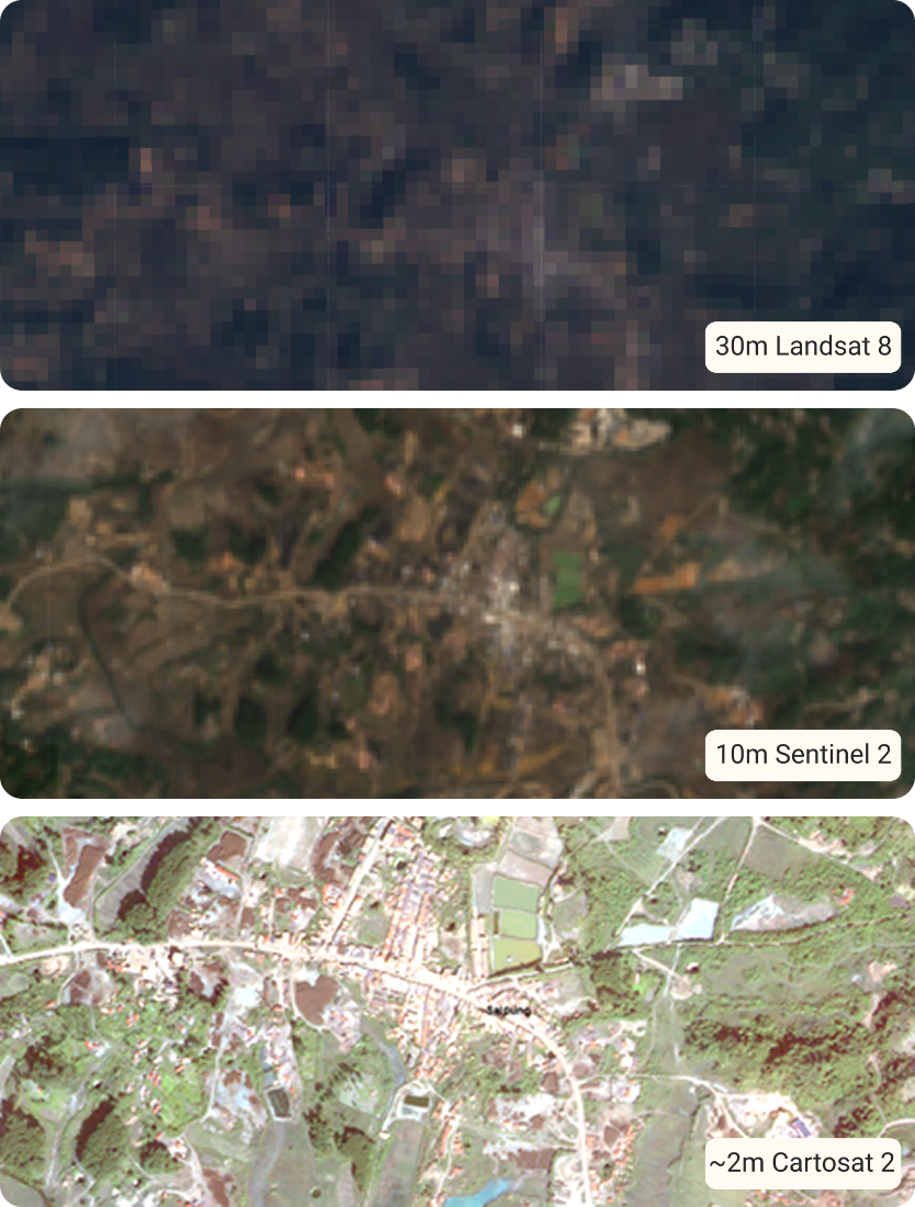
High-resolution satellite imagery, combined with advanced remote sensing techniques and machine learning models, allows for a more precise understanding of carbon sequestration in tree-based systems – agroforestry, forests, and other landscapes. Resolution of satellite images plays a crucial role in accurately detecting individual trees and assessing their biomass.
Where lower-resolution images may struggle to differentiate smaller trees or tree crowns, leading to inaccuracies in carbon measurements, high-resolution satellite images (<1 meter) provide more precise data, including of tree size and canopy area, helping improve the accuracy of biomass and carbon estimation.
One of the major benefits of using high-resolution satellite imagery for carbon mapping in agroforestry is its ability to scale across large areas. Satellites can cover hundreds to thousands of hectares of land, allowing for mapping of carbon sequestration in vast, remote or otherwise inaccessible areas.
This is a cost-effective alternative to traditional field-based inventories, which are labor-intensive, time-consuming, and often limited to smaller sample areas.
Two ways in which satellite imagery supports data collection to assess project viability:

High-resolution satellite imagery (such as from WorldView or GeoEye) can capture detailed information about tree crowns (canopy area) and tree species, which are key indicators for estimating carbon storage. By using machine learning models (like deep learning algorithms), satellite data can precisely detect and map individual trees, even in densely vegetated areas. This is important for accurately estimating carbon storage in agroforestry or non-forest landscapes, where trees are often mixed with crops or are present in varied density.
Detecting Tree Crown
Detecting Tree Crown

Satellite data combined with algorithms and allometric models can relate tree characteristics – crown area and stem diameter – to biomass and estimate that for individual trees or entire stands. Biomass is the primary basis for calculating carbon storage as trees sequester carbon in their biomass (trunk, branches, leaves).
The relationship between crown size (measured from satellite imagery) and biomass (estimated) is used to assess carbon content – carbon typically makes up about 50% of the biomass of trees.
Estimating Biomass
To accurately measure tree biomass and carbon sequestration,
three new scientific and technical developments must be considered:

Increasing access to extremely high-resolution satellite data
Nature investments are more viable today than ever before. Environmental markets, mechanisms and instruments have gained maturity, and carbon markets are leading the path for such investments. Carbon finance is a win-win for investors, corporations, communities and natural ecosystems, with these emerging markets serving as the cornerstone of investments in sustainable land-use. Nature investments are also contributing to the expansion of bio-economy markets that are moving the world in the direction of green growth

Increasing access to extremely large amounts of satellite data with enough computer processing power
The images detect light reflected from the surface in map elements called pixels and each pixels dimension is 50 cm by 50 cm, which is much smaller than a whole tree crown. Machine learning algorithms cluster the tree crown pixels into polygons delineating the whole crown.
We need to know the size of each tree to measure its mass – the biomass. While satellite images do a very good job of mapping individual tree crowns, most allometric scaling models use stem diameter as the best predictor of biomass.
Standard practice in forestry for decades has been to use species wise equations to estimate tree biomass from measures of stem diameter. Sometimes the added dimension of tree height is also used.
Allometric models are rather difficult to develop, and there is perhaps more error in this basic component of the measurement than all other components, including the remote sensing elements. But these are the estimators that have been conventional and accepted practice for decades.

Development of new AI/machine learning models to detect individual trees and estimate biomass
Increasing access to extremely large amounts of satellite data with enough computer processing power:
The remote sensing contribution adds critical capabilities:
- scaling measurements over large areas
- making routine re-visit measurements, and
- mapping of all individual trees rather than having to sample as is the current convention.
The advantage provided by new VHR satellite data and machine learning models is the ability for the first time to use standard and conventional allometry used routinely by the forestry sector, instead of the generalized statistical estimators used in previous remote sensing classifiers.
To accurately measure tree biomass and carbon sequestration,
three new scientific and technical developments must be considered:
Increasing access to extremely high-resolution satellite data
Nature investments are more viable today than ever before. Environmental markets, mechanisms and instruments have gained maturity, and carbon markets are leading the path for such investments. Carbon finance is a win-win for investors, corporations, communities and natural ecosystems, with these emerging markets serving as the cornerstone of investments in sustainable land-use. Nature investments are also contributing to the expansion of bio-economy markets that are moving the world in the direction of green growth
Increasing access to extremely large amounts of satellite data with enough computer processing power
The images detect light reflected from the surface in map elements called pixels and each pixels dimension is 50 cm by 50 cm, which is much smaller than a whole tree crown. Machine learning algorithms cluster the tree crown pixels into polygons delineating the whole crown.
We need to know the size of each tree to measure its mass – the biomass. While satellite images do a very good job of mapping individual tree crowns, most allometric scaling models use stem diameter as the best predictor of biomass.
Standard practice in forestry for decades has been to use species wise equations to estimate tree biomass from measures of stem diameter. Sometimes the added dimension of tree height is also used.
Allometric models are rather difficult to develop, and there is perhaps more error in this basic component of the measurement than all other components, including the remote sensing elements. But these are the estimators that have been conventional and accepted practice for decades.
Development of new AI/machine learning models to detect individual trees and estimate biomass
Increasing access to extremely large amounts of satellite data with enough computer processing power:
The remote sensing contribution adds critical capabilities:
- scaling measurements over large areas
- making routine re-visit measurements, and
- mapping of all individual trees rather than having to sample as is the current convention.
The advantage provided by new VHR satellite data and machine learning models is the ability for the first time to use standard and conventional allometry used routinely by the forestry sector, instead of the generalized statistical estimators used in previous remote sensing classifiers.

Accurate Carbon Measurements for Nature-based Solutions (NbS) and Carbon Financing
Ultimately, it is accurate measurements that equip financial institutions with reliable projections that guide investments and advance the transition to a low-carbon economy driven by NbS. Quantifying and Verifying Carbon Sequestration is a crucial pillar of such measurements.
To learn about other ways in which accurate measurements can help scale investments in viable nature projects, download this document.
Download PDF
How Accurate Measurements help Investors
De-Risking Through Reliable Data
Banks rely on good quality data to conduct risk assessments across sectors. Similarly, nature investing requires reliable data on ecosystems health and productivity to assess risks and security of an investment. Measuring indicators like carbon sequestration rates, forest growth, or water quality allows the prediction of project stability and identifies risks such as threat of deforestation or biodiversity loss that could affect long-term outcomes.
Maximizing Environmental and Financial Returns
Measurement isn’t just about reducing risk, it also ensures that the quality of the investment remains high. Understanding how nature dependencies affect value chains, crop yields, and resource availability can allow investors to avoid investments vulnerable to ecological disruptions. For example, measuring dependencies on nature helps price risks accurately and allocate funds towards resilient, sustainable investments.
Quantifying Co-Benefits and Multiplying Impact
High-quality nature investments often deliver co-benefits like improved biodiversity, community resilience, and water security. Metrics provide quantifiable evidence of these additional benefits, which can attract socially responsible investors and open opportunities for premium returns, especially where co-benefits align with Environmental, Social, and Governance (ESG) goals.
Preventing Greenwashing and Ensuring Credibility
Measurement brings accountability, helping avoid the reputational risks of “greenwashed” projects that claim sustainability without evidence. With transparent metrics, it can be verified that projects deliver genuine, measurable benefits, thereby strengthening their position in sustainable finance and building trust with clients.
Alignment with Reporting Standards
Reliable measurement enables investors to meet regulatory requirements and industry standards, such as those set by the Task Force on Climate-related Financial Disclosures (TCFD) These frameworks depend on rigorous data to classify and validate sustainability claims, ensuring that investors can confidently report to stakeholders on the real impact of their investments in nature.
Building Trust with Clients and Investors
Reliable measurements can offer clients and investors greater transparency in nature investments by presenting verified metrics. By demonstrating precisely how an investment impacts carbon reduction, biodiversity enhancement, or secured water resources, stakeholders can be reassured of the project’s integrity and effectiveness.


